The project proposed by the consortium of 2001, HHF Architekten, TER, Systematica, Transsolar and Cabane for the Wunnquartier Stade at the beginning of December. The members of the jury saw it as "a site that remains in the service of the city, a strong signal for the use of public land".
This project is based primarily on the reuse of the existing site to transform it into a new residential area in the city. This choice reflects a responsible approach to the challenges of the future, based on the potential of the site, its legacy and its buildings. This approach is marked by a strong gesture: preserving parts of the existing stadium to transform it into a new public space, a park open to the inhabitants of the neighbourhood, the surrounding area and the city at large.
In addition to integrating this element into the new urban plan, the group has developed a project that integrates rainwater into the development with fewer sealed surfaces than at present, limits earth movements, has a circular approach to the existing building, offers flexibility in programming, and integrates soft mobility, citizen participation and social diversity.
The advantages of the stadium
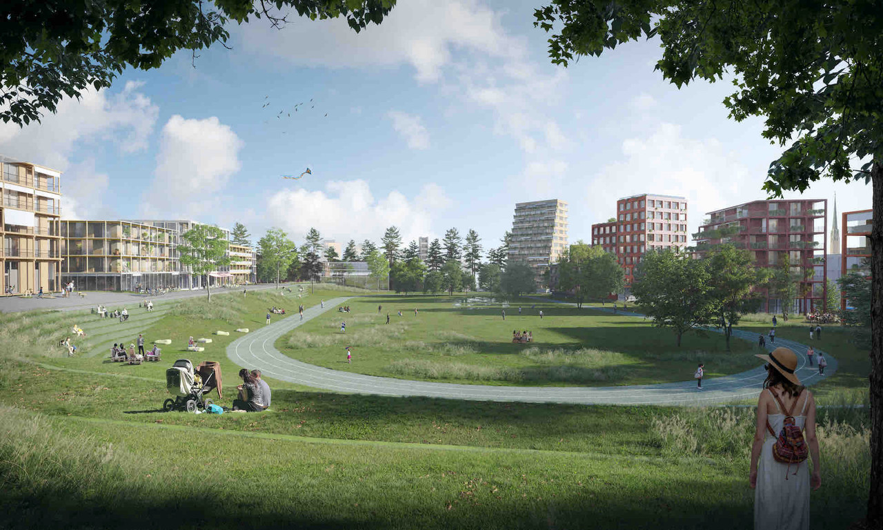
The transformation of the stadium into a public park is an important statement given the pressure on land in Luxembourg. The land, which was previously a public gathering place, will remain open for shared use and continues the tradition in Luxembourg of organising new residential areas around a park. The stadium acts as a unifying agent, ensuring the memory of the place remains present in the collective imagination.
It is also part of an urban green grid--a network composed of the municipal park, the Merl park and the Tony Neumann park.
Moreover, it has a predefined form, a specific spatiality that it is interesting to exploit. The idea of retaining the terraces allows both to keep a trace of the previous use and to structure the existing topography.
Different urban atmospheres
Different urban contexts can develop around this "unifying urban figure", as the group describes it.
The edge of the plateau overlooks Rollingergrund and benefits from views towards Limpertsberg, Kirchberg and the city centre. This space, which extends from Rue Napoléon 1er and Rue du Stade, becomes a shared space, conducive to walking thanks to a hillside wood. It extends as far as the route d'Arlon via a lookout point that opens up visually onto the city.
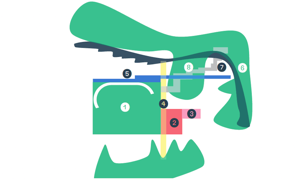
1-Parc du Stade, 2-Place Josy Barthel, 3-Caserne Cultures Urbaines, 4-Rambla/Pinède, 5-Esplanade, 6-Promenade du Belvédère, 7-Diagonal path, 8-Inhabited wood (Illustration: 2001-HHF Architekten)
Further south, topographical terraces, which are part of this site, accommodate the residential spaces.
Along the route d'Arlon, an urban fringe becomes the new address of the district. There are emblematic buildings and a new public square animated by the spaces of the barracks and the old stables, which have been preserved and rehabilitated for new functions. It is a permeable zone, with the tram stop the epicentre of the new district.
A peaceful neighbourhood
The entire district will be calm in terms of mobility. Pedestrians and cyclists will have priority. The only vehicular access to the district will be from the barracks area, behind which there will be a semi-subterranean car park. Rue du Stade will be maintained, but will become a landscaped area, a mineral space with drainage and pine trees. This axis extends beyond the route d’Arlon to the Belair sports park.
At the western end of the site, a pedestrian and cycle path extends the existing path from Belair. It leads to a new pedestrian and cycle esplanade overlooking the stands to the north. Behind the barracks, parallel to the route d’Arlon and the new esplanade, a new alleyway provides access for deliveries, fire and sanitation services. A pedestrian path crosses the site diagonally and connects the Rollingergrund rise to the Stade park.
Different scales
The district is also characterised by the creation of different scales. The large scale is used for the urban front along the Arlon road with the public square and the park. It also includes the former barracks and the new international school that will be developed around the villa currently used for the crèche.
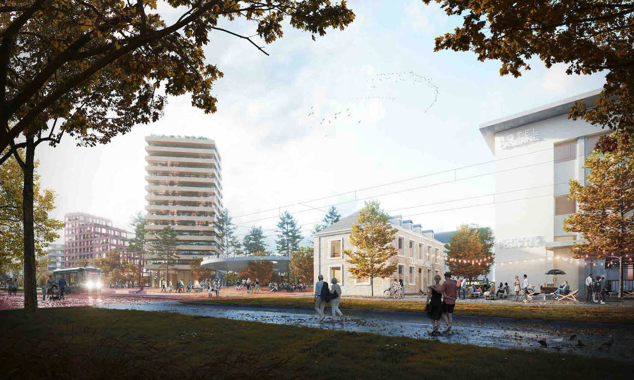
View of the project from the Arlon road, with the old barracks, a new public square and new high-rise buildings. (Illustration: 2001-HHF Architekten)
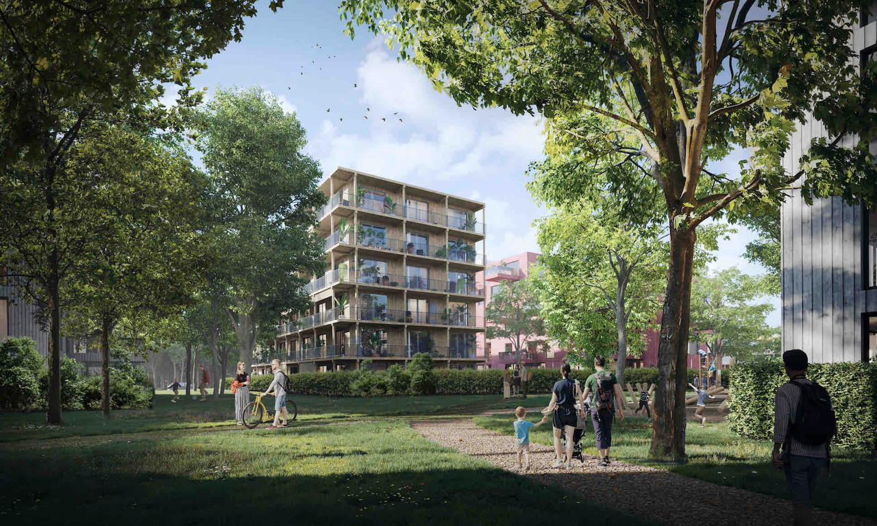
A smaller scale is also used to create neighbourhoods and stimulate cohesion. In the park, and following the example of existing parks in the city (Villa Vauban, Villa Louvigny, etc.), four villas will be built on the south side. They will be able to accommodate various functions representative of contemporary society, such as a house for senior citizens, a student house, etc. To the north of the old stadium, three residential blocks are developed in the form of a closed area with private gardens, vegetable gardens and common facilities. These blocks are mainly for residential use, but also include a crèche and flexible catering facilities overlooking the park.
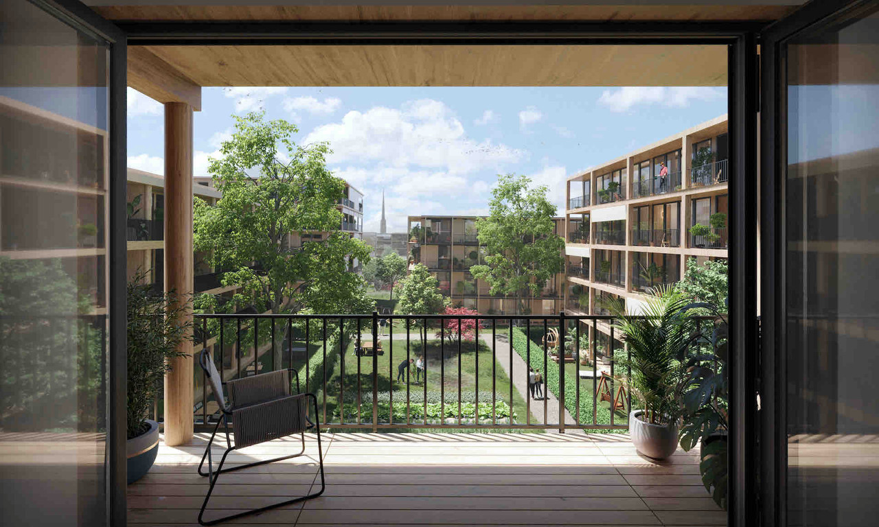
View from a dwelling to the shared space within the block. (Illustration: 2001-HHF Architekten)
To the east of these blocks is the "inhabited wood" which is structured by the esplanade and the diagonal path. The topography, which is more marked in this area, is exploited to integrate a covered car park with premises for craftsmen and professionals. Covered with two metres of arable land, the whole area is intensively planted. Thanks to this inertia, the car park could eventually become a data centre or a battery centre for renewable energy.
View of the circulation spaces within the "inhabited wood". (Illustration: 2001-HHF Architekten)
At the end of the site blocks follow the slope and take advantage of the landscape.
Finally, the southern slope is inhabited by four blocks that open up towards the Belair sports park. Note that this development is optional.
A project that remains flexible
The project foresees that the building volume can be adapted, offering flexibility in terms of investment and operational speed and leading to a social mix within the blocks. The orientation of the buildings is optimised to provide solar protection and natural ventilation, thus contributing to the reduction of energy needs.
The ground floors will be predominantly inhabited with small outdoor spaces allowing for setbacks and buffer zones. The larger spaces will be shared in the heart of the blocks with functions such as laundry rooms, bicycle storage, party spaces or mini co-working spaces, in the spirit of the shared economy.
The entire development is to be carried out in phases. The first construction sites will be the barracks and the former stables, the current crèche and the Franciscan sisters' site. Then the recycling centre and the stadium will be developed. The last section will be along the route d'Arlon.
This story was first published in French on . It has been translated and edited for Delano.
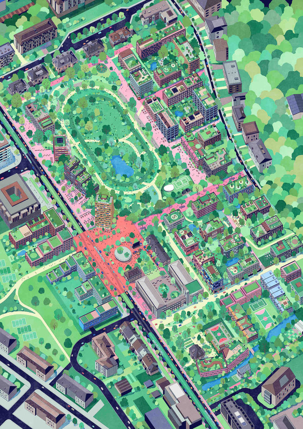
General illustration of the new district. (Illustration: 2001-HHF Architekten)